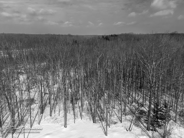
A view looking over a forest in Central New York
Being curious as to what the view was like looking over the top of the forest near my house, I sent my drone up into the air to capture the view.
 |
| A view from about 100 feet above the ground looking over the top of the forest. |
This view is due north from about 100 feet/30 meters above the ground. The tree lying on the ground, near the bottom right of the photograph, is about 70-80 feet tall. In the middle-left of the photograph, through the trees is the Seneca River. The river is about 800 feet away from the camera. At the time the photograph was taken the river was mostly frozen over.
Image details:
- Captured in DNG format, using a DJI Mini 2.
- Edited in Adobe Camera Raw and Photoshop.
- Drone altitude, 420 feet/128 meters above sea level.
Photograph taken on February 8, 2022, near Syracuse, New York.


Cool! We have been considering getting a drone. Are you happy with this one? I have heard many stories about people losing their drones due to connectivity. That's kind of what is holding us back. Any thoughts on that?
ReplyDeleteThanks, Shelly.
DeleteI'm happy with this drone. I chose it because it wasn't outrageously expensive, and it could capture images in DNG (RAW format).
In my limited experience with drone flying, I haven't had any issues with losing connectivity. It's possible that people who this is happening to aren't following the rule of keeping a line-of-sight to the drone. If you don't keep line-of-sight, then foreign objects could interfere with the remote's and drone's communication. In fact, FAA rules state you must keep a line-of-sight to the drone while flying it.
Thank you for the response. I think in one case it was line of sight. These were older ones as well so I imagine things have improved by now as well. I need to look into them more. They look like a lot of fun.
DeleteAlso, if you haven't make sure to take a look at the FAA's Drone Zone: https://faadronezone.faa.gov . Lots of info there on rules and such.
DeleteThank you! That site is quite informative.
Delete